

Preview
Document Type
StillImage
Contributing Institution
Maine State Archives
Identifier
206949
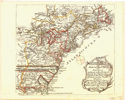
Description
Rare map of the British Colonies at the conclusion of the French & Indian War, originally engraved by Georg Christoph Kilian and included in Heiden's Americanische urquelle derer innerlichen kriege des bedrängten Teutschlands. The map extends to just beyond the Mississippi River and locates a number of forts, Indian Tribes, and rivers. It also notes Walker's Settlement of 1750, the 1665 and 1738 limits of the Carolina Colonies, and the boundaries of the Hudson Bay Company.
Broad Creation Date
1762
Dimensions
8.5" x 11"
Language
German
Other Location
New England; North America
Keywords
Cartography; Maps; British Colonies